Communities
Communities Details
The Planning Department helps shape growth and development in the County by working with communities to create neighborhoods where people live, work, and play. Through the process of comprehensive planning, planners work with community members, like residents, workers, property owners, and students, to come together and share their ideas and goals for how their area should grow, change, or be preserved in the future.
Our guiding principles come from the County’s general plan, Plan Prince George’s 2035 (Plan 2035). Planners also use master, sector, and transit district development plans to guide planning in smaller areas of the County.
Regions
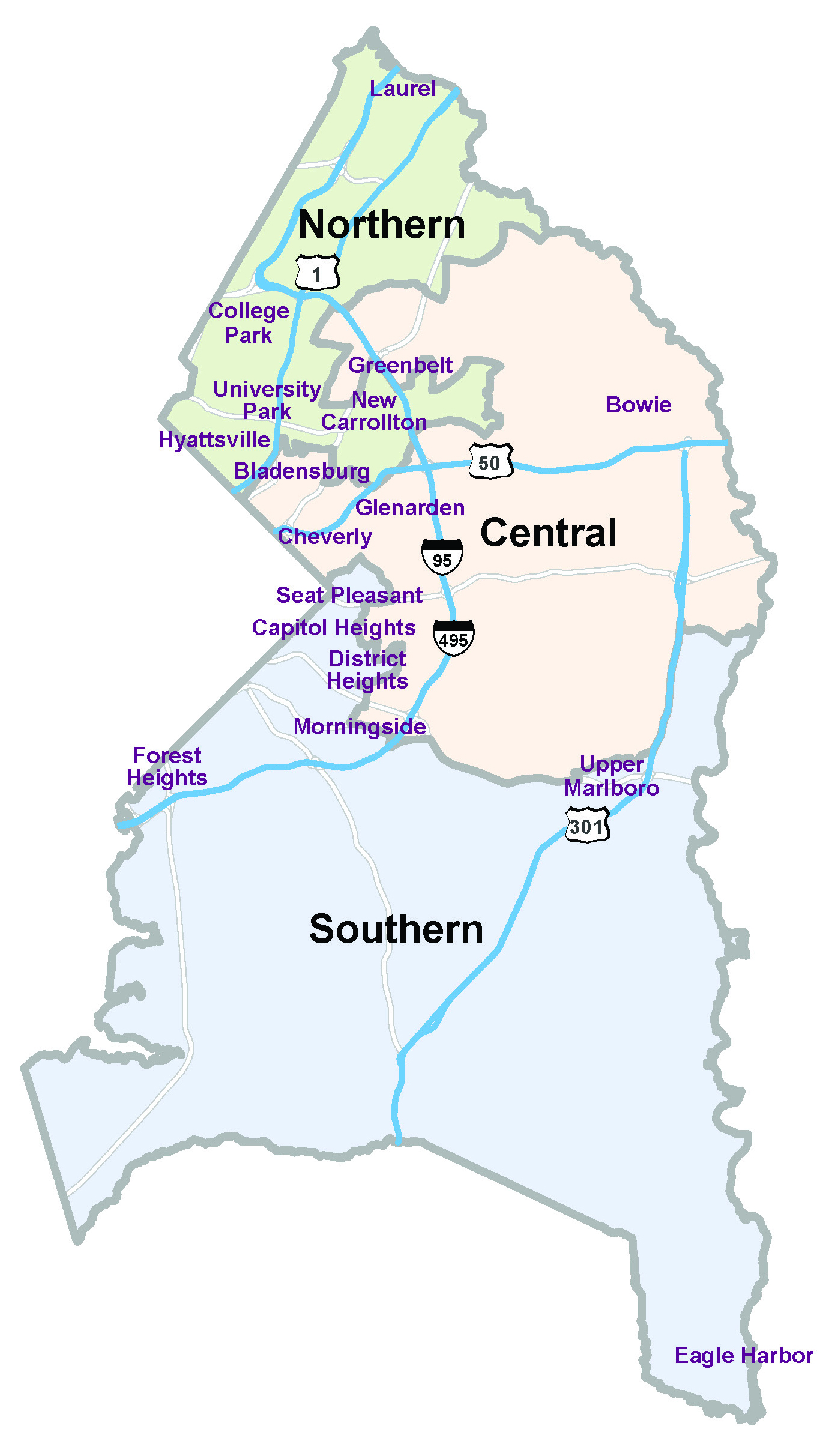
For planning purposes, we divide the County into three regions, each made up of three council districts.
Northern
Councilmanic Districts: 1-3
Municipalities:
- Berwyn Heights
- Brentwood
- Cheverly*
- College Park
- Greenbelt*
- Hyattsville*
- Landover Hills*
- Mount Rainier
- New Carrollton
- North Brentwood
- Riversale Park
- University Park
* Municipalities that cross over more than one district.
Central
Councilmanic Districts: 4-6
Municipalities:
- Bladensburg
- Bowie
- Cheverly*
- Colmar Manor
- Cottage City
- Edmonston
- Fairmount Heights
- Glenarden
- Greenbelt*
- Hyattsville*
- Landover Hills*
- Morningside*
* Municipalities that cross over more than one district.
Southern
Councilmanic Districts: 7-9
Municipalities:
- Capitol Heights
- District Heights
- Forest Heights
- Morningside*
- Seat Pleasant
- Upper Marlboro
* Municipalities that cross over more than one district.
NOTE: The City of Laurel has its own planning and zoning authority.
Community Programs

Planning Assistance to Municipalities and Communities (PAMC)
Learn more
Sustainable Communities
Learn More
Partnership for Action Learning in Sustainability
Learn more
Cultural Arts in Prince George’s County
Learn moreWhat’s included in a Community Planning Project?
Master & Sector Plans
A master plan provides specific recommendations for a subregion or planning area regarding land use, the environment, historic preservation, housing, commercial and employment areas, economic development, urban design, transportation, and public facilities. Sector plans perform the same function as a master plan but focus on a smaller geography that exhibits special circumstances. For example, a sector plan may cover the area around a Metro station.
Sectional Map Amendments
A sectional map amendment is the comprehensive rezoning of a subregion, planning area, or specific geography within a planning area. It generally occurs concurrently or shortly after the approval of a master or sector plan and is an important component in its initial implementation.
Minor Amendments
A minor amendment is the modification of an approved master or sector plan to correct an inconsistency or error within a plan, or to respond to changing conditions in the Plan Area.
Planning Studies
Planning studies are conducted to provide detailed information on one or more of the components found in a master or sector plan, such as transportation, economic development, etc.
Implementation Projects
Implementation projects relate to recommendations found in a master or sector plan and can cover any of the plan elements.
FAQs
What is comprehensive planning?
Comprehensive planning is the process through which residents, workers, property owners, students, and other stakeholders identify their vision for the future growth, development, or preservation of their community. Prince George’s County’s comprehensive plan is Plan Prince George’s 2035 (Plan 2035).
Plan 2035 is further refined at the local level by the County’s 38 area master, sector, and transit district development plans. You can find out more about these plans at the Find a Plan or Project page.
For more information, please call 240-524-8413.
Whom can I contact regarding planning issues in my area?
A list of Community Planning Division staff and their community planning responsibilities is shown on the Area Planner Map.
Where can I access videos of recent public meetings?
Recent public meetings are made available on the Planning Department’s YouTube channel. Subscribe to the channel to stay engaged as projects develop in the County.
Can our staff provide planning / design assistance to your city, town, or community?
Yes. Staff are available to provide planning and design assistance to your city, town, and community. Our professionals possess skills in many specialized areas such as architecture, landscape architecture, urban design, and transportation planning. The Maryland-National Capital Park and Planning Commission offers a Planning Assistance to Municipalities and Communities Program. This program is available upon written request to:
Chairman of the Prince George’s County Planning Board
1616 McCormick Drive
Largo, Maryland 20774
For further details and examples of eligible projects for design assistance, please refer to the Planning Assistance for Municipalities and Communities (PAMC).
What is the difference between a master plan and a sector plan?
Pursuant to State law, the Zoning Ordinance divides Prince George’s County into 37 Planning Areas. The Planning Department groups these Planning Areas into seven (7) Subregions. A master plan for a Subregion, a Planning Area, or more than one Planning Area is called an “Area Master Plan.”
A master plan for portions of one or more Planning Areas is called a “Sector Plan.” A master plan created for areas designated in the pre-2018 Zoning Ordinance as Transit District Overlay Zones are called “Transit District Development Plans.” All of these (area master, sector, and transit district development plans) have the same applicability as master plans. The County currently has 38 active master plans.
Each master plan is an amendment to the County’s General Plan.
How are sector and master plans prepared?
The Planning Department works closely with community stakeholders to develop area master and sector plans. The process of developing a plan includes data gathering and analysis, inclusive and extensive public and stakeholder engagement, evaluating scenarios for future growth, identifying a vision for the future of an area, and articulating the necessary policies and strategies to implement that vision. Master and sector plans have a 20- to 25-year horizon.
Once drafted, a preliminary, or staff draft, master or sector plan is released to the public for review and comment. Following a public hearing, a master or sector plan is adopted by the Prince George’s County Planning Board. The adopted plan is then presented to the Prince George’s County Council, sitting as the District Council. Once approved by the District Council, plan recommendations guide decisions concerning land use, housing and neighborhoods, the natural environment, transportation and mobility, community heritage, culture, and design, public facilities, economic prosperity, and healthy communities that affect the physical growth and development of the area so that consistent and appropriate action may be taken. Adopted and approved plans do not take the place of existing zoning, nor do plans require that rezoning requests be automatically granted or denied. They do, however, provide a basis for comprehensive rezoning consistent with the recommendations of the plan. In most instances, immediately following or concurrently with approval of a master or sector plan, the Planning Board initiates comprehensive rezoning, also called a sectional map amendment.
For more information, please call 240-524-8413.
What is the Plan Prince George’s 2035?
The Plan Prince George’s 2035 is the County’s General Plan that helps guide future growth, development, and public investments in Prince George’s County. It establishes policies and strategies to achieve the County’s long-term vision.
The General Plan reflects the values and priorities of the County’s residents, property and business owners, community leaders, and elected officials, while also establishing broad policies on:
- Land Use
- Economic Prosperity
- Transportation & Mobility (rail, road, bus, pedestrian, bicycle)
- Natural Environment
- Housing and Neighborhoods
- Community Heritage, Culture, and Design
- Healthy Communities
- Public Facilities
For more information, please visit www.planpgc2035.com or call 240-524-8413.
What are functional plans?
Functional master plans are countywide in scope and are generally prepared at the request of the District Council. Functional plans amend the General Plan where appropriate; they have been prepared for highways, historic sites, parks and recreation, trails, schools, and public safety. Presently, the county is preparing a functional plan for transportation (Master Plan of Transportation).
For more information, please call 301-952-4225.
What is a sectional map amendment (SMA)?
A sectional map amendment (SMA) is a comprehensive rezoning amendment for properties within an entire geographic area, such as a subregion, planning area or part of a planning area. The purpose of an SMA is to revise zoning patterns to conform to recommendations of the applicable master or sector plan. SMAs are adopted for most plans with the exception of the general plan and functional master plans.
For more information, please call 240-524-8413.