Planning Assistance to Municipalities & Communities
Planning Assistance to Municipalities & Communities Details
Planning Assistance to Municipalities & Communities (PAMC) funds experts for your Prince George’s County planning project—technical assistance, mobility, environment, historic preservation, community engagement, revitalization, mapping, research, and more. Municipalities and communities in Prince George’s County can apply here. Check out the active and completed projects in the tabs below, then tell us about your project ideas! Email staff at pamc@ppd.mncppc.org.
Active Projects
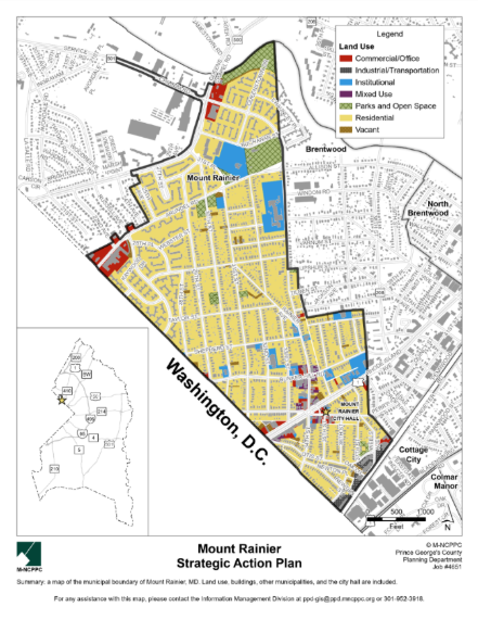
Strategic Action Plan for the City of Mount Rainier
Project Planner
Planner II, Neighborhood Revitalization Section
PHONE: 301-952-5389
EMAIL: maha.tariq@ppd.mncppc.org
Update
The Strategic Action Plan for the City of Mount Rainier was approved for funding by the Prince George’s County Planning Board on June 18, 2026. The project will kick off in September, 2026.
Project Description
The City of Mount Rainier seeks to prepare a Strategic Action Plan that will provide clear, actionable, short-, medium-, and long-term strategies to strengthen city government operations, service delivery, and community outcomes. The plan will function as a roadmap for city leadership and staff, aligning policies, programs, and investments with community priorities and the city’s fiscal and administrative capacity. As Mount Rainer is part of the Regional District, the plan will not recommend changes to zoning, development regulations, or future land use designations. It can, however, direct the city to participate in regional planning efforts and work to ensure those outcomes are influenced by the city’s priorities. Aligned with the City’s Mission, Vision, and Values Strategy, which will be developed for city adoption as part of this plan, and individual city departmental visions, the plan would set goals and provide actionable strategies to promote and prioritize economic development, achieve job growth, increase public safety, strengthen emergency preparedness, adopt environmentally sustainable practices, act on climate change, improve infrastructure and transportation, conduct good governance and citizen engagement, and enhance the overall quality of life for everyone in Mount Rainier.
Project Boundary
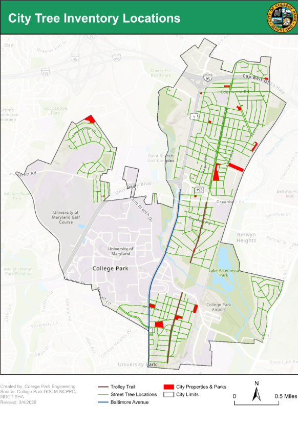
Urban Forest Inventory and Management Plan for the City of College Park
Project Planner
Planner II, Neighborhood Revitalization Section
PHONE: 301-780-2233
EMAIL: anusree.nair@ppd.mncppc.org
Update
The Urban Forest Inventory and Management Plan for the City of College Park PAMC project was approved by the Prince George’s County Planning Board on June 18, 2026. The project will kick off on June 26, 2026.
Project Description
College Park completed an urban tree canopy study in 2023 that concluded the city’s urban forest is under threat, and that a ground-based inventory is essential to reversing that trend. The city needs a “living” inventory to proactively manage tree health and risk, plan trimming and maintenance on a species-based cycle, support permitting and regulatory requirements, and reduce reactive or emergency work, and identify where additional trees can be planted. This project will produce a management plan to identify strengths and weaknesses, set goals, and anticipate funding needs. The management plan report will include information on overall tree health conditions, age distribution, size, species, tree population data, maintenance needs, tree threats, and key findings. It will also discuss the different needs of the four city districts on city streets (including Edmonston Road), the Trolley Trail, and the 12 city parks, and it will outline collaborative opportunities for tree planting in the six M-NCPPC neighborhood parks within the city boundaries.
Project Boundary
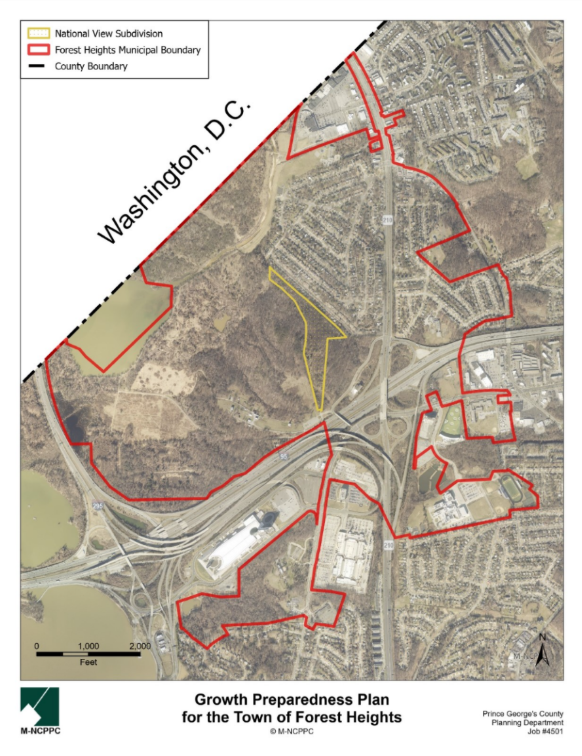
Growth Preparedness Plan for the Town of Forest Heights
Project Planner
Planner III, Neighborhood Revitalization Section
PHONE: 301-952-4609
EMAIL: connor.klein@ppd.mncppc.org
Update
The Forest Heights Growth Preparedness Plan was approved for funding by the Prince George’s County Planning Board on June 18, 2026.
Project Description
The 21-acre mixed-use development of National View has received preliminary plan of subdivision and conceptual site plan approvals. A detailed site plan was approved by the Planning Board on November 20, 2025. The Town of Forest Heights strongly supports the development, noting the project includes 33,698 square feet of retail space, a municipal police office, a daycare center, new trails, a dog park , and a public amphitheater. Further, the project would diversify the town’s long-term revenue base and would provide housing options for residents, especially seniors, to allow them to remain in the community as their needs change. When completed, National View would add 1,562 multifamily units (including 505 for elderly housing) and 71,918 square feet of commercial development to the town, greatly increasing its population. Understandably, the town wishes to plan for this population growth. While the certificate of adequacy for the National View meets the required levels of service for transportation, pedestrian and bikeway facilities, parks and recreation, police residential use, fire and rescue, and schools, this project aims to determine the anticipated demands on additional facilities and services controlled by the town.
Project Boundary
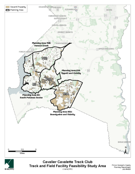
Cavalier-Cavalette Track Club Facility Feasibility Study
Project Planner
Update
The Cavalier-Cavalette Track Club Facility Feasibility Study PAMC project was approved for funding by the Prince George’s County Planning Board on June 18, 2026
Project Description
This project will explore and study the feasibility of the Cavalier-Cavalette Track Club (CCTC) constructing its own track and field facility for the use of CCTC members for practice, meets, and rental income. The facility would be designed for multi-use activation with considerations for lighting, seating, signage, security , and a flexible layout for non-athletic events, such as festivals and farmers’ markets. The project will identify up to five sites of 10 acres each in the southwest portion of the County suitable for development of a track and field facility for use by CCTC. Advantages and constraints of each potential site will be explored. The project report will provide a feasibility analysis, estimates of construction and, if applicable, maintenance costs, and potential funding and implementation partners.
Project Boundary
Maryland Inventory of Historic Properties for the Anacostia Trail Heritage Area
Project Planner
Update
The Maryland Inventory of Historic Properties for the Anacostia Trail Heritage Area (ATHA) PAMC project was approved for funding by the Prince George’s County Planning Board on June 18, 2026.
Project Description
The Maryland Inventory of Historic Properties will be a critical planning tool for creating and updating heritage routes, connecting historical themes across the County, and identifying cultural tourism destinations and gaps in historically significant topics for which ATHA will seek funding to fill. Planning for important projects such as the Civil Rights Trail and celebration of the American Semiquincentennial (July 4, 2026) will rely on it. In future years, the more complete inventory will be used to update the 2001 ATHA Management Plan—the County’s oldest active functional master plan. The major deliverables for the project include individual county assessment reports and an overview report summarizing the state of MHT’s Architectural Research and Survey Program.
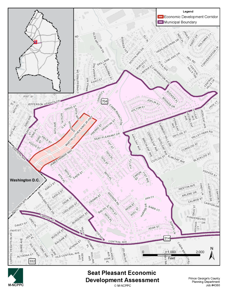
Seat Pleasant Economic Feasibility Assessment
Project Planner
Planner III, Neighborhood Revitalization Section
PHONE: 301-952-4609
EMAIL: connor.klein@ppd.mncppc.org
Project Description
This project to promote commerce and economic development will build on the 2019 PAMC-funded MD 704 Streetscape Enhancement 30% Design and Engineering Report, which made recommendations to better accommodate and improve safety and mobility for pedestrians and bicyclists within the available right-of-way.
The objective of the assessment is to analyze the current market and economic conditions of Seat Pleasant, a gateway community to and from the District of Columbia. The research will produce a detailed report outlining the city’s capacity for economic growth and to offer strategic recommendations for enhancing the community’s economic prospects. This project will build upon the findings of the Central Avenue Blue/Silver Line Sector Plan’s existing conditions report, incorporating those insights while tailoring strategies to meet the needs identified by city staff. The assessment will propose actionable strategies for the municipality to foster sustainable quality economic development. The focus area identified for this project is the properties on either side of MD 704 (Martin Luther King, Jr. Highway) from 69th Place to the District of Columbia border.
The assessment will be developed using County data, contributions from city staff and elected officials, business and property owners, field surveys, and analysis and interpretation by the consultant. The final work product will be a report.
Project Timeline
| Milestone | Description | Date |
|---|---|---|
| Project Kickoff | Stakeholders gathered for the project kickoff. | March 24, 2025 |
| Field Tour | The project team joined Seat Pleasant officials for a walking tour of the study area to catalogue community characteristics, priority areas, existing conditions, and assess needs. | June 18, 2025 |
| City Council Presentation | The Economic Development Assessment was presented to the Seat Pleasant City Council. | October 6, 2025 |
| Final Report | Look for the final plan will be published on or near to this date. | June 2026 |
Project Boundary
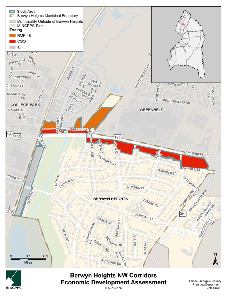
Berwyn Heights NW Corridor Economic Development Strategy
Project Planner
Planner III, Neighborhood Revitalization Section
PHONE: 301-952-4609
EMAIL: connor.klein@ppd.mncppc.org
Updates
Staff are finalizing the Draft Strategy which is expected to be published in August.
Project Description
Lands with zones in Berwyn Heights conducive to development—IE (Industrial, Employment), RMF-48 (Residential, Multifamily-48), and CGO (Commercial, General and Office)—are found in the Town’s northwest corridors: Greenbelt Road to the north and Ballew Avenue to the west. The Town of Berwyn Heights is seeking to examine these commercial corridors and analyze the local economic context; identify economic opportunities and resources; and collaborate with stakeholders to anticipate needs and opportunities created by the Beltway Plaza redevelopment and the potential FBI headquarters facility (֫in Greenbelt.) This project would analyze, interpret, and understand the current market and economic conditions of the study area in these zones, develop a report that details the capacity of the study area for economic growth and provide recommendations to improve upon and advance the interests of not only the Town of Berwyn Heights but those of the adjacent cites—College Park and Greenbelt.
The project aims to produce a detailed report outlining the Town’s capacity for economic growth along these corridors and to offer strategic recommendations for enhancing the community’s economic prospects. The assessment will propose actionable strategies for the municipality to foster sustainable quality economic development. The assessment will be developed using County data, contributions from city staff and elected officials, business and property owners, field surveys, and analysis and interpretation by the consultant. The final work product will take the form of a report.
Project Boundary
Project Timeline
| Milestone | Description | Date |
|---|---|---|
| Project Kickoff | Stakeholders gathered for the project kickoff. | August 19, 2025 |
| Field Tour | The project team joined Berwyn Heights officials for a walking tour of the study area. | October 9, 2025 |
| City Council Presentation | The Berwyn Heights Economic Development Strategy was presented to the Berwyn Heights Town Council | April 6, 2026 |
| Final Report | Look for the final report to be published on or about this date | June 2026 |
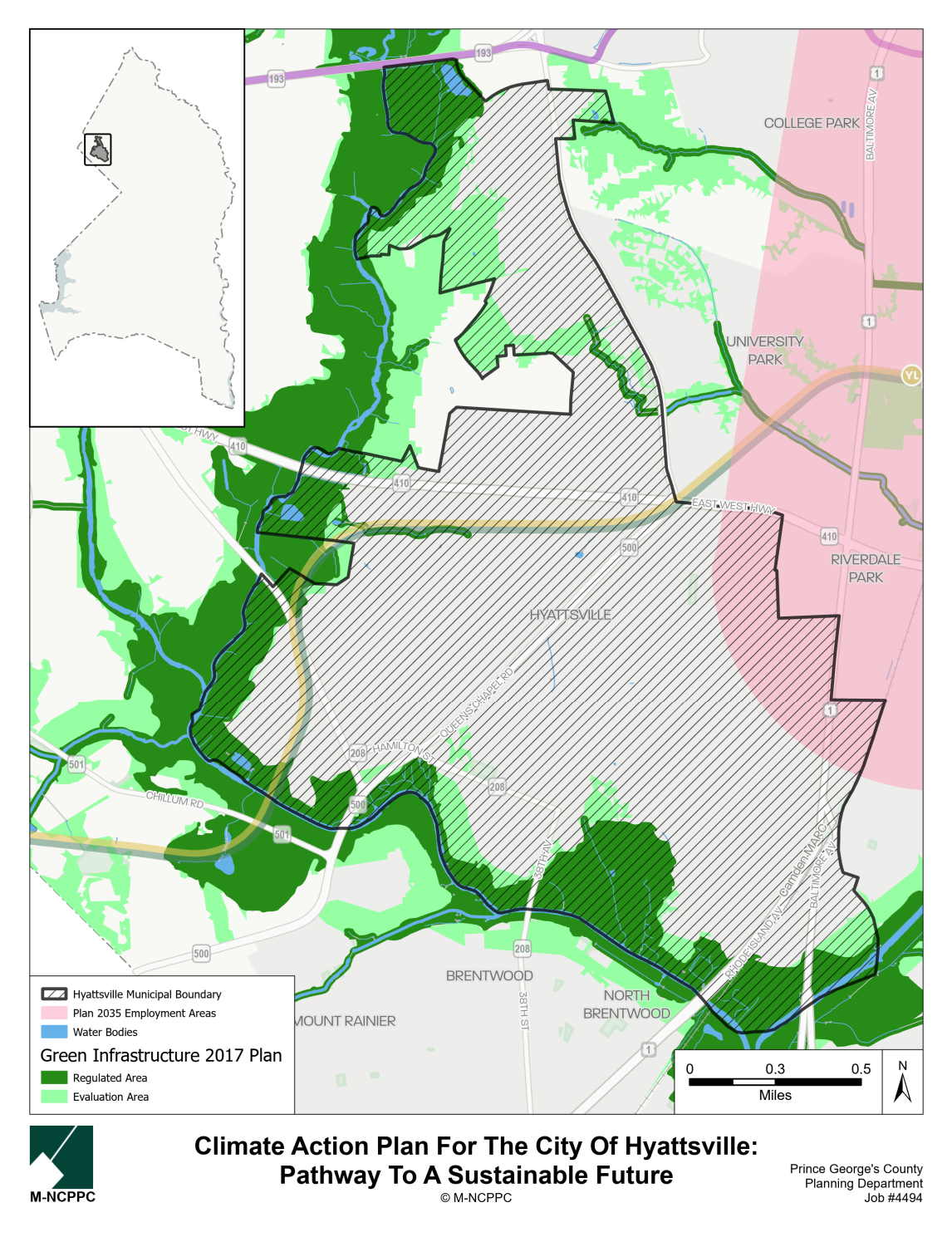
Hyattsville Climate Action Plan
Project Planner
Planner II, Neighborhood Revitalization Section
PHONE: 301-780-2233
EMAIL: anusree.nair@ppd.mncppc.org
Updates
UMD School of Public Policy in consultation with consultants and the City developed a community survey to gauge the impressions of the citizens of Hyattsville on climate change. The survey results guide the plan’s priorities. For a summary of the survey responses, follow the hyperlink to the survey report. To see the more detailed survey results, follow the hyperlink to the topline results.
Project Description
The Hyattsville Climate Action Plan will set sustainability and climate action goals for the City to meet, organize and prioritize action steps to achieve the goals, and galvanize and unify key stakeholders in shared sustainability practices. The plan will help the City to advance environmental justice and transition to a state of readiness for and adaptation to climate change and identify where the City can contribute toward County CAP goals achievement. The project includes an intensive, door-to-door climate change and sustainability survey designed and implemented by the University of Maryland School of Public Policy’s Saul I. Stern Civic Engagement Research Lab students; two Greenhouse Gas Emissions Community Inventories compiled by the Maryland-Washington Council of Governments, and consultants’ participation in a Hyattsville community event to further engage residents. The final plan will include an executive summary, prioritized risks and potential actions, and a road map for using the results of the findings.
Project Boundary
Project Timeline
| Milestone | Description | Date |
|---|---|---|
| Kick-Off & Refinement of Work Plan | July 2025 | |
| Tour | The consultant will take an in-person tour of the study area existing conditions and assess the needs identified by City staff. | November 2025 |
| Greenhouse Gas (GHG) Emissions Inventories | September – November 2025 | |
| Review of Material, Plan Outline, & City Work Session | City Work Session #1 Work session with the Hyattsville Environment Committee to discuss the plan outline and identify resources, focus areas, key stakeholders, capacities, and opportunities. Brief Presentation to City Council A brief about the project and a revised plan outline incorporating input received during the work session will be presented to the Hyattsville City Council at a regularly scheduled City Council meeting. | July 2025 – January 2026 |
| Identification and Prioritization of Potential Actions | December 2025 – March 2026 | |
| City Work Session #2 | Work session with the Hyattsville Environment Committee to present the inventory findings and the forecast and solicit input and prioritization of the draft mitigation and adaptation actions. | Feb/March 2026 |
| Climate Survey Coordination | UMD School of Public Policy in consultation with consultants and the City developed a community survey to gauge the impressions of the citizens of Hyattsville on climate change. The survey results guide the plan’s priorities. For a summary of the survey responses, follow the hyperlink to the survey report. To see the more detailed survey results, follow the hyperlink to the topline results. | August 2025 – February 2026 |
| Stakeholder Feedback on Strategies | Consultants conducted strategic conversations with key stakeholders, including elected officials, businesses, and non-profit organizations. | February – March 2026 |
| Outreach Event | Community engagement at the Hyattsville 140th Anniversary Festival to share the draft proposals for reducing GHG emissions and strengthening the City in the face of climate events. | April 2026 |
| Draft Climate Action Plan | Consultant shall prepare the draft plan and present it to City officials and staff at a regularly scheduled, public City Council meeting for comment. | March – July 2026 |
| Final Climate Action Plan | July – August 2026 | |
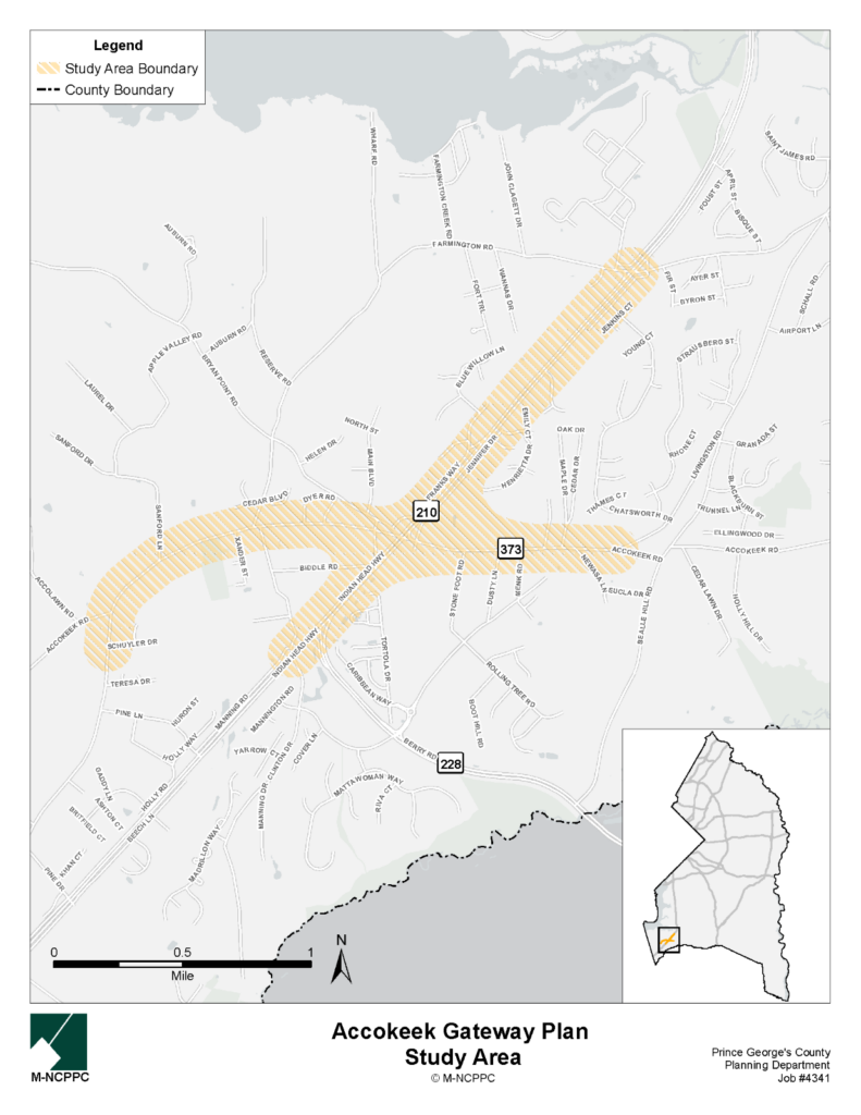
Accokeek Gateway Plan
Project Planner
Planner II, Neighborhood Revitalization Section
PHONE: 301-780-2233
EMAIL: anusree.nair@ppd.mncppc.org
Project Updates
Community Meeting Materials
On November 19, 2025, we held a community meeting to discuss preliminary ideas for the Accokeek Gateway Plan. View the presentation and exhibits.
Project Description
The PAMC-funded 2023 Accokeek Heritage Tourism Study recommends the development of a gateway plan that would be centered on the intersection of MD 210 and MD 373. The plan notes, “It has long been observed that MD 210 divides Accokeek into two parts, and, in some respects, into two communities. For example, majority of the approximately 7,000 acres to the northwest of the highway is either zoned AG (Agricultural and Preservation) or ROS (Reserved Open Space), while there are only 142 acres of ROS southwest of it, and no AG-zoned lands. In consideration of this aspect, it was determined by residents that the highway could not be reimagined as Accokeek’s ‘main street.’ Nevertheless, MD 210 has a major visual impact on Accokeek’s landscape. With that in mind, a shift in mindset is suggested: to not consider MD 210 as a divider but instead to focus on the highway as a gateway to Accokeek. From this perspective, MD 210 and the intersection with MD 373 (Livingston Road) present an opportunity to communicate to visitors that they have arrived at a special place and that their presence is welcome.” This new project will focus on a two-mile portion of MD 210, from Manning Road East north to Farmington Road; and a 2.2-mile portion of MD 373 (Livingston Road) from Schuyler Drive, east to Accokeek Road. The plan will identify and evaluate challenges and opportunities.
The project goals include improving travel safety, particularly for pedestrians; identifying ways in which a gateway to the community can be established, one that identifies Accokeek as a welcoming community for those who live here and those who travel through the area; identifying potential economic growth and viability for Accokeek property owners and service providers along the corridor; and generally improving aesthetics and thereby improving livability. Since there is no public signage to acknowledge Accokeek or identify it as a community of any type, a basic project goal is to identify appropriate signage. A steering committee of eight members selected by GACA will guide the project.
Project Boundary
Project Timeline
| Milestone | Description | Date |
|---|---|---|
| Project Kickoff and Refinement of Work Plan | Stakeholders gathered for the project kickoff. | March 26, 2025 |
| Field Tour | The project team joined members of the Greater Accokeek Civic Association, steering committee and elected officials for a tour of the study area. | May 22, 2025 |
| Steering Committee Work Session #1 | The project team presented their observations and worked with the committee in a virtual meeting to solidify issues, resources and primary informants . | August 20, 2025 |
| Stakeholder Engagement Meeting | The project team presented preliminary gateway improvement ideas to members of the Greater Accokeek Civic Association, steering committee and the broader Accokeek community to gather feedback and additional ideas at the Accokeek Volunteer Fire Hall. Community members who could not attend the stakeholder engagement meeting also had the opportunity to provide feedback via an online comment form. | November 19, 2025 |
| Steering Committee Work Session #2 | The project team presented the draft plan to the steering committee in a virtual work session to receive feedback. | May 28, 2026 |
| Final Plan | The final plan will be published on or near this date. | July – August 2026 |
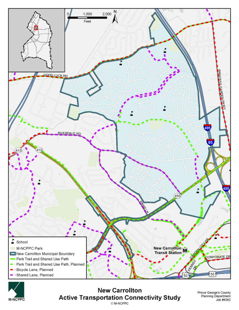
New Carrollton Active Transportation Connectivity Study
Project Planner
Planner II, Neighborhood Revitalization Section
PHONE: 301-952-5389
EMAIL: maha.tariq@ppd.mncppc.org
Project Description
Several 2009 Approved Countywide Master Plan of Transportation (MPOT) planned bike facilities cross through and border the City of New Carrollton but they offer only indirect routes when connecting places within and outside the city. For example, planned shared-use roadways and side paths from the Metro station double-back on themselves before reaching the city’s northern border.
New Carrollton’s only trail is the .64-mile recreational loop at West Field, which according to the city is well-used by joggers, bicyclists, walkers, and dog walkers. New Carrollton is a multimodal transportation hub, with access to Metro, MARC, Amtrak, and the future Purple Line. An improved bikeway system would, in theory, allow people to travel to New Carrollton and from there to almost any destination in the continental United States, car-free. This active transportation connectivity study for the City of New Carrollton will evaluate and diagnose pedestrian and bicyclist facility deficits and propose a system of intracity bikeways, sidewalks, and natural surface trails providing sustainable, safe, and equitable transportation options and more recreational opportunities within the municipal boundary. The proposed bikeways will connect with the MPOT planned bikeways, especially where they connect important extra-municipal destinations, such as the New Carrollton Metro Station. The study will build on the recommendations in the forthcoming New Carrollton Downtown Access & Connectivity Strategy. Also evaluated will be the status of secure bicycle parking facilities at major activity centers and make recommendations for improvement consistent with best practices, including Section 27-6309 of the Prince George’s County Subdivision Regulations.
Project Boundary
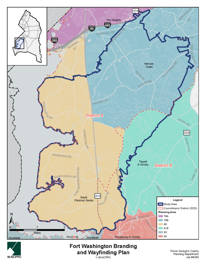
Fort Washington Branding and Wayfinding Plan
Project Planner
Planner II, Neighborhood Revitalization Section
PHONE: 301-952-5389
EMAIL: maha.tariq@ppd.mncppc.org
Project Description
Fort Washington Forward, Inc., a nonprofit organization, was awarded funding for a consultant to develop a Branding and Wayfinding Plan for the greater Fort Washington community. Formed in December 2021, Fort Washington Forward’s mission is to 1) attract smart/holistic investment to the Fort Washington community that accentuates retail, the environment, and parks and recreation, and 2) enhance social connectivity and sustainability in the community. For this project, branding is that which differentiates a community or place by capturing its unique collective identity and representing it in a distinct manner using visual cues, words, and phrases. A successful brand unites the community and captures the imagination of people outside the area. Wayfinding is that which helps people successfully navigate through an area using visual and other sensory cues such as signs or mapping. Wayfinding tools and resources help orient people to their current location and assist them in planning and following a route to reach a different destination.
The branding component will use community engagement to identify significant cultural, historic, and natural resources, define a Fort Washington boundary, and establish a Fort Washington brand to capture a shared identity and project a positive message by which the community can be known and recognized by residents, visitors, homebuyers, and businesses, and their customers. The wayfinding component will inventory existing amenity signage and signage conditions, and, using the branding components developed, establish what future signage should look like and where the signage should be located to highlight the region’s amenities and identify the location as “Fort Washington.”
The final logo, created with guidance from a resident steering committee and two community engagement sessions, is shown below:
View or download the Final Presentation Slides here.
Project Boundary
Flooding & Stormwater Hazard Mitigation Analysis for Brentwood & North Brentwood
Update
At a public meeting hosted by the Town of Brentwood on May 01, 2025, consultants Charles P. Johnson and Associates presented the Draft Flooding and Stormwater Hazard and Risk Management Analysis for the Towns of Brentwood and North Brentwood.
Project Planner
Planner II, Neighborhood Revitalization Section
PHONE: 301-780-2233
EMAIL: anusree.nair@ppd.mncppc.org
Project Description
Located within the Anacostia Watershed along the Northwest Branch of the Anacostia River, approximately 164 acres, or 66 percent, of improved properties in the Town of Brentwood and 70 acres, or virtually 100 percent, of those in the Town of North Brentwood are located in a FEMA-designated flood zone, which does not account for climate change events. Although some work has been undertaken to identify which properties are prone to flooding and what causes it, and to mitigate it through infrastructure improvements, the towns lack a comprehensive understanding of current conditions and future predictions. Residents regularly experience flooding with extreme rain events, sometimes creating or exacerbating financial hardships and health problems.
The purpose of the project is to provide the towns with data and tools to assess key current and possible hydrometeorological hazards, as well as their vulnerability and options for risk reduction and mitigation, and:
- Identify all private and municipal properties, infrastructure, and natural resources with flooding and/or stormwater hazard
- Identify the causes of those risks
- Categorize properties and infrastructure by flooding and/or stormwater risk
- Identify potential mitigation measures for each category
- Identify areawide infrastructure-related potential mitigation actions and analyze the regulatory structure required to implement such actions; and
- Provide an analysis report and data that can be incorporated into the Brentwood Climate Action Plan, and used as a standalone document by both towns, working independently and together to reduce or eliminate flooding and stormwater as hazards.
Project Boundary
Sustainable Brentwood: A Climate Action Plan
Project Planner
Planner II, Neighborhood Revitalization Section
PHONE: 301-780-2233
EMAIL: anusree.nair@ppd.mncppc.org
Project Description
Sustainable Brentwood will be a climate action plan that adapts and uses, as necessary and appropriate, the recommendations of the 2022 Prince George’s County Draft Climate Action Plan. The plan will set sustainability and climate action goals for the town to meet, organize, and prioritize action steps to achieve the goals, and galvanize and unify key stakeholders in shared sustainability practices. The Brentwood Climate Action Plan (CAP) will help the town advance environmental justice, transition to a state of readiness for and adaptation to climate change, and identify where the town can contribute toward achieving County CAP goals, given the municipality’s unique population and circumstances.
The planning process will engage key community stakeholders (residents, businesses, and community groups), allowing community responses to shape the plan guidance and describe what steps need to be taken for the town to achieve climate resilience and mitigate climate disasters such as drought, heat, storms, and flooding. The plan will consider recent federal, state, and County legislation to incentivize sustainability and climate change preparedness and apply it to Brentwood’s particular circumstances. As with the County’s draft plan, inclusion and equitable planning and strategies are priority commitments, as the effects of climate change can be demonstrably punitive to disadvantaged and vulnerable populations. The concurrent Flooding and Stormwater Hazard and Risk Management Analysis for the Towns of Brentwood and North Brentwood, Maryland, will also inform the project.
Project Boundary
| Project | Applicant | Completed |
|---|---|---|
| College Park Municipal Grant Writing Workshop | City of College Park | The Municipal Grant Workshop Series included four sessions held from February-April 2026 and was open to all municipal staff in Prince George’s County. The slides from all four sessions can be found here. |
| Greenbelt Strategic Wayfinding Plan | City of Greenbelt | June 2026 |
| Walker Mill CDC Youth Wellness & Opportunities Assessment | Walker Mill Community Development Corporation (CDC) | February 2026 |
| Chesapeake Beach Rail Trail Segment Feasibility and Design Study | Town of Upper Marlboro | August 2025 |
| Community Center Feasibility Study for the Town of Cottage City | Town of Cottage City | August 2025 |
| Marlboro Pike Market Feasibility Assessment | Marlboro Pike Partnership Community Development Corporation | August 2025 |
| Bowie State of Place | City of Bowie | April 2025 |
| Capitol Heights Vacant Lot Strategy | Town of Capitol Heights | March 2025 |
| Town of Riverdale Park Community Forest Management Plan | Town of Riverdale Park | February 2025 |
| Berwyn Heights Pedestrian and Bicycle Safety Improvement Action Plan | Town of Berwyn Heights | August 2024 |
| Cheverly National Register Nomination | Town of Cheverly | The Cheverly Historic District was listed in the National Register of Historic Places on July 5, 2024. The nomination can be found here. |
| Accokeek Heritage Tourism Study | Greater Accokeek Civic Association, Accokeek Foundation, Alice Ferguson Foundation | June 2023 |
| Town of Edmonston Economic Development Strategy | Town of Edmonston | May 2023 |
| Aquasco-Woodville Cultural Resources Inventory Technical Report | Cedar Haven Civic Association on the Patuxent River, Inc. | April 2022 |
| The Houses of Fairmount Heights, Maryland: A Pattern Book | Town of Fairmount Heights | April 2022 |
| 2021 City of New Carrollton Economic Development Strategy | City of New Carrollton | August 2021 |
| Completed: Crime Prevention Through Environmental Design | City of Hyattsville | July 2019 and July 2020 |
| 2018 Historic Fairmont Heights High School Adaptive Reuse Economic Study | Town of Fairmount Heights | January 2019 |
| Logo, Brochure, and Branding Plan | Town of Cottage City | June 2019 |
| Bladensburg Market Feasibility and Economic Analysis | Town of Bladensburg | May 2022 |
| Youth Survey | City of Seat Pleasant | 2018 |
| City of College Park Age-Friendly Action Plan | City of College Park | October 2022 |
| Prince George’s County Healthy Corner Store Initiative Guidance and Toolkit | Institute for Public Health Innovation | December 2022 |
| Anacostia Trails Heritage Area Wayfinding and Signage Study | Anacostia Trails Heritage Area | March 2023 |
| Seat Pleasant Streetscape Improvements | City of Seat Pleasant | October 2019 |
| Northern Gateway SPACEs Report | Northern Gateway Community Development Corporation | September 2021 |
| The Village of Brandywine Sidewalk and Streetscape Improvements Study: 30% Design and Engineering Report | Black Swamp Creek Land Trust, Inc. | October 2021 |
| 2021 City of College Park Complete and Green Streets Implementation Plan | City of College Park | April 2021 |
Contact Us
Planner IV, Neighborhood Revitalization Section
PHONE: 301-952-3166
EMAIL: daniel.sams@ppd.mncppc.org
Planner III, Neighborhood Revitalization Section
PHONE: 301-952-4609
EMAIL: connor.klein@ppd.mncppc.org