Carole Highlands Safe Mobility Study
Carole Highlands Safe Mobility Study
This project has been completed and can be viewed here.
Project Summary
The objective of the Carole Highlands Safe Mobility Study is to work with the community and partner agencies to develop transportation planning and design options that maximize safe mobility and enhance access and connectivity to the Purple Line, University Boulevard, and other important community-identified destinations. This will include implementable opportunities (that improve safety, access, and connectivity) while also fostering equitable economic development.
Background
The Prince George’s Planning Department sought to conduct a study of the Carole Highlands area, focusing on the pedestrian experience. The study will examine existing conditions, and, working with the local community and partner agencies, identify opportunities for improving pedestrian safety and accessibility.
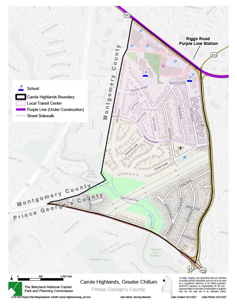
Carole Highlands is an approximately 210-acre community located in the north west of Prince George’s County. This community is bounded by the County line to the west, MD 193 (University Boulevard) to the north, MD 212 (Riggs Road) to the east, and MD 410 (East West Highway) to the south. The portion of Carole Highlands north of Hannon Street is predominantly commercial. See the project map page, which shows where sidewalks and driveways were present in 2017.
The most recent planning department document that includes Carole Highlands is the 2015 Greater Chillum Community Study. The project concentrates on developing a comprehensive list of needs and improvement strategies with an emphasis on defining and facilitating neighborhood conservation, pedestrian safety and access, and commercial revitalization strategies and programs.
The residential sections have good connectivity, but residents must reach the commercial area via large connector roads. Most of the streets in this portion of the neighborhood do not include sidewalks. The section of single-family homes in Carole Highlands south of the high-tension line right-of-way are made up of two communities: a portion of Park Lawn and Riggs Park Estates. These communities do not have any vehicular connections to the northern portion of Carole Highlands. This area has good interconnectivity, even though it is isolated by the power line easement and major connectors. The southern area of Carole Highlands has sidewalks on all streets.
Objectives
- Improve public safety and economic development by improving connectivity between the community sections and to existing retail through an improved streetscape.
- Create pedestrian connections between community sections and to MD193 and other key routes in the area.
Timeline
| Date | Milestone |
|---|---|
| February 8, 2022 | Kick-off Meeting |
| April 8, 2022 | Site Visit/Walking Audit with Partners and Stakeholders |
| June 2022 | Community Walk Audit/Community Meeting |
| November 2022 | Draft Report Presentation (Community Meeting # 2) |
| October 2023 | Final Report |
Map