Minor Amendment to the Subregion 5 Sector Plan and SMA

Project Contact Information
Kierre McCune
TEL: 301-952-3211
EMAIL: kierre.mccune@ppd.mncppc.org
Korey Arsenault
TEL: 301-952-4317
EMAIL: korey.arsenault@ppd.mncppc.org
The Prince George’s County Planning Department is preparing an amendment to the 2013 Approved Subregion 5 Master Plan and Sectional Map Amendment. This minor plan amendment will create a forward-looking, market-viable framework to guide investment and economic development while enhancing the quality of life for residents and workers in the area.
Guided by the Plan Prince George’s 2035 General Plan, the plan amendment will combine public participation, real estate market analysis, land use and zoning review, and regional best practices to shape updated planning recommendations. The recommendations will be organized into plan elements, including land use, open space, economic development, housing, and transportation. The aim is for the plan amendment to align growth, development patterns, and infrastructure planning with current conditions and community priorities.
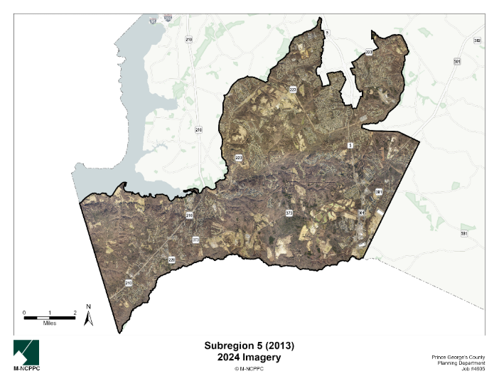
Subregion 5 covers approximately 74 square miles, including the Clinton, Accokeek, and Brandywine communities, as well as some rural and agricultural areas that are outside the Plan 2035 growth boundary.
The amendment to the Subregion 5 Master Plan is being carried out in tandem with the Subregion 6 minor plan amendment, which is adjacent to Subregion 5.
The planning process will feature three listening sessions, offering opportunities for residents, businesses, and stakeholders to share their preferences and priorities for the scale, character, and implementation of future development in Subregion 5.
Map
Timeline
| Milestone | Expected Timelines |
|---|---|
Listening Sessions | Fall 2025 |
| Initiation | Spring 2026 |
| Joint Public Hearing | Summer 2026 |
| Planning Board Adoption | Summer 2026 |
| Council Approval | Fall 2026 |
Project Documents
FAQs
How can I participate in the planning process?
This planning process features a unique community engagement approach designed to specifically capture resident and stakeholder feedback to inform the development of the plan amendment. We’re hosting listening sessions in November 2025 that will feature a brief presentation and interactive engagement opportunities. Stay tuned to this project webpage and our social media channels to stay updated about listening sessions near you.
What is a Minor Plan Amendment?
A minor plan amendment is an update to an existing approved master plan or sector plan. Minor plan amendments are initiated by the County Council through a formal resolution. A plan amendment is classified as “minor” if it affects less than 50% of the area of the existing approved plan.
What is a Sectional Map Amendment?
A sectional map amendment (SMA) is a comprehensive rezoning amendment for properties within an entire geographic area, such as a subregion, planning area, or part of a planning area. The purpose of an SMA is to revise the zoning of property to conform to the recommendations of the applicable master plan or sector plan. An SMA is being done concurrently with this plan amendment and will recommend zoning changes for specific properties to achieve the sector plan’s vision and goals.
What part of the county is in Subregion 5?
Subregion 5 is one of seven subregions in Prince George’s County, located in the southwestern and southern portion of the County. The Subregion is approximately 74 square miles in size and constitutes approximately 15 percent of the County’s total land area. Subregion 5 forms much of the southern boundary with Charles County and acts as the southern gateway into Prince George’s County. The Subregion is served by major highways including Indian Head Highway (MD 210), Branch Avenue (MD 5), and Robert Crain Highway (US 301). While no municipalities are contained in Subregion 5, the plan boundary contains five important Census-designated, County-historical communities: Accokeek, Brandywine, Clinton, Piscataway, and Tippett.
Why is part of MD 5 (Branch Avenue) excluded?
The portion of MD 5 (Branch Avenue) spanning from the Southern Maryland Hospital Center area to the Allentown Road-Suitland Road corridor is carved out of the Subregion 5 Master Plan area. This corridor is subject to the 2013 Approved Central Branch Avenue Corridor Revitalization Sector Plan.
What is zoning?
Zoning is the law that determines what can be built, where it can be built, and how it is built. Zoning works in two parts. The zoning ordinance is the written law and the zoning map shows where the different zoning regulations are applicable. There are several different types of zones including Residential, Industrial, Commercial, Agricultural, Open Space, and Transit-Oriented zones. Associated with these zones are a list of land uses that are allowed and not allowed inside of them, for example, heavy industrial uses are not typically allowed in residential zones, but different types of homes are likely allowed. Different zones also have different permitted heights, densities, setback requirements, etc., all of which change the way the streetscape looks and feels.
What are the implications of any zoning changes on a property in Subregion 5?
If the planning process recommends rezoning, that will happen at the end of the planning process through a legal update to the County Zoning Map. Even if a property is rezoned, nothing can physically happen to the property unless the owner initiates a change (e.g., sale or redevelopment). Keep in mind that sector plans only produce recommendations for the future; no change can occur to a privately owned property unless initiated by the owner.
How will I know if my property is recommended for a different zone?
If your property is recommended for rezoning through this and SMA, you will be notified through US mail, per 27-3407 Scheduling of Hearings and Public Notice of the Zoning Ordinance. Plan and zoning recommendations are evaluated through:
- A public comment period through the Joint Public Hearing (Planning Board and District Council) process
- Work sessions
Should the County Council recommend additional amendments to the sector plan and/or SMA that were not raised in testimony at the Joint Public Hearing, they must hold an additional Joint Public Hearing on those amendments.
The Prince George’s County Planning Department welcomes and encourages public participation and feedback throughout the plan development and public review period. Note that it is the County Council that has the power to approve the plan and authorize changes to the zoning map
Does a change in zoning mean I am at risk of losing my property?
No. A master plan is aspirational and outlines goals and makes recommendations for the future of a planning area over a 25-year period. Master plans and zoning regulations do not remove ownership or impose development mandates on property owners. If a property owner wants to redevelop a property after the County approves a zoning change through the sectional map amendment then the requirements of the property’s new zoning classification would apply.