Central Avenue-Blue/Silver Line Sector Plan and SMA
Central Avenue-Blue/Silver Line Sector Plan and SMA

Central Avenue-Blue/Silver Line Sector Plan and SMA
TEL: 301-780-9610
EMAIL: CABL@ppd.mncppc.org
William (Bill) Skibinski
TEL: 301-952-3572
EMAIL: william.skibinski@ppd.mncppc.org
Elena Perry
TEL: 301-780-8156
EMAIL: elena.perry@ppd.mncppc.org
Kierre McCune
TEL: 301-952-3211
EMAIL: kierre.mccune@ppd.mncppc.org
Updates
Scheduled Joint Public Hearing
The Prince George’s County Planning Board and the County Council will hold a Joint Public Hearing on Tuesday, March 10, 2026, at 6:00 p.m. The hearing will take place at the Wayne K. Curry Administration Building (1301 McCormick Drive, Largo, MD) to receive public testimony on the Preliminary Central Avenue–Blue/Silver Line Sector Plan and Proposed Sectional Map Amendment (SMA).
Register to Speak or Submit Testimony
- Use the Council’s eComment portal: https://pgccouncil.us/Speak
- Email written comments to onlinesignup@co.pg.md.us
- On‑site registration will be available, but advance registration is strongly encouraged
- Speakers will have 3 minutes for oral testimony
- Written comments will be accepted until the close of business on Wednesday, March 25, 2026
Affidavit Requirement for Zoning Intensification
The Proposed SMA includes potential zoning intensification within the SMA boundaries.
If you plan to request or support zoning intensification in your oral or written testimony, you must file an affidavit under the State Public Ethics Law (General Provisions Article §§5‑833–5‑839).
Deadline: Affidavits must be submitted via the eComment portal or emailed to onlinesignup@co.pg.md.us no later than Friday, February 6, 2026.
Failure to file by the deadline may delay or prevent the District Council from considering your testimony.
Ex Parte Communication Disclosure
Under Section 2‑296 of the Prince George’s County Code and General Provisions Article §5‑836:
- Any communication with a County Council Member or the County Executive regarding the plan or SMA must be disclosed.
- An ex parte disclosure form must be filed within five (5) working days of the communication.
Affidavit Forms (Maryland State Ethics Commission):
- Individuals: https://ethics.maryland.gov/wp-content/uploads/filebase/local-gov/local-gov-forms/PGNO1.pdf
- Entities: https://ethics.maryland.gov/wp-content/uploads/filebase/local-gov/local-gov-forms/PGNO2.pdf
- Agents: https://ethics.maryland.gov/wp-content/uploads/filebase/local-gov/local-gov-forms/PGNO3.pdf
Special Ethics Law Memo:
https://ethics.maryland.gov/wp-content/uploads/filebase/local-gov/local-gov-forms/PG-County-Zoning.pdf
For questions about affidavits or ex parte disclosures, contact the Maryland State Ethics Commission at 410‑260‑7770.
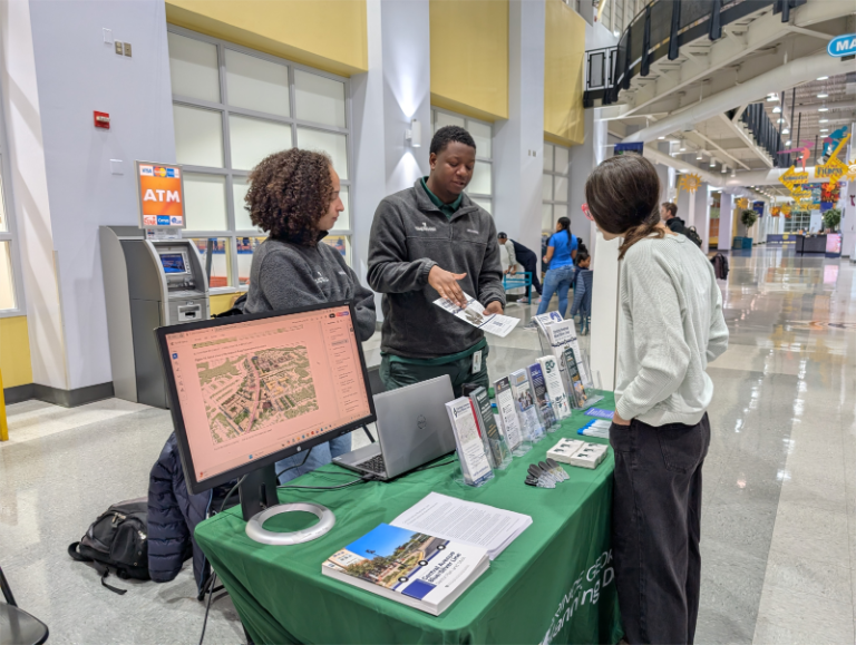
Preliminary Sector Plan and Proposed Sectional Map Amendment Office Hours Events
We are excited that the preliminary sector plan and proposed sectional map amendment are now available for public review. To bring awareness about this important milestone, staff have arranged office hours to answer any questions and discuss the preliminary sector plan and proposed sectional map amendment. This is a great opportunity to learn about the next steps!
Staff hosted the first office hours on Thursday, November 13, 2025, at the Prince George’s County Sports and Learning Complex from 2:30 p.m. to 6:30 p.m. Thank you to all who stopped by!
Missed Us?
Don’t worry! The next Office Hours event will be held on December 10, 2025, at the Peppermill Community Center from 4:00 p.m. to 7:00 p.m.
Your voice matters—stop by, say hello, and stay informed!
Release of the Preliminary Sector Plan and Proposed Sectional Map Amendment
On September 18, 2025, the Prince George’s County Planning Board voted to publicly release the first draft of the Preliminary Central Avenue-Blue/Silver Line Sector Plan and Proposed Sectional Map Amendment (SMA). The sector plan and SMA are available for review/download here.
Review a physical copy of the preliminary plan and proposed SMA at the following locations:
- City of Seat Pleasant City Hall, 6301 Addison Road, Capitol Heights, MD 20743
- Town of Capitol Heights Town Hall, 1 Capitol Heights, MD 20743
- Sports and Learning Complex, 8001 Sheriff Road, Landover, MD 20785
- Peppermill Community Center, 610 Hill Road, Capitol Heights, MD 20785
- Cedar Heights Community Center, 1200 Glen Willow Drive, Capitol Heights, MD 20743 (until the Seat Pleasant Activity Center reopens)
- M-NCPPC Largo HQ, Planning Information Services, 1616 McCormick Drive, Largo, MD 20774
Request your own physical copy by contacting the team through email at CABL@ppd.mncppc.org or by phone at 301-780-9610.
Next Steps!
The Prince George’s County Planning Board and County Council will hold a Joint Public Hearing in expected to be scheduled in early 2026 at the Wayne K. Curry Administration Building (1301 McCormick Drive, Largo, Maryland 20782) to hear public testimony regarding the Preliminary Central Avenue-Blue/Silver Line Sector Plan and Proposed Sectional Map Amendment (SMA). The joint public hearing presents the community with an opportunity to testify about their thoughts on the preliminary plan and SMA live in front of members of the District Council and Planning Board.
More information about how to register to speak or submit comments or written testimony will be shared after the Joint Public Hearing has been scheduled. Sign up to receive project updates in your inbox at pgplan.org/blueemail.
Extension to the Timeframe for Preparation of the Staff Draft Central Avenue-Blue/Silver Line Sector Plan and Sectional Map Amendment
Recent feedback from key stakeholders highlighted the need for greater density in strategic areas. To accommodate substantial revisions to the plan’s text, maps, organizational structure, and urban design visualizations, the project team requested a six-month extension to the project timeline, shifting the Permission to Print deadline to September 25, 2025. Watch the Planning Board meeting recording here. The County Council approved the requested extension on March 11, 2025, via Agenda Letter LTR 03112025b.
The project team presented an update on the draft sector plan during the October 10th, 2024, Planning Board meeting. Updated urban design visualizations, proposed recommendations, and zoning changes were discussed. As part of the presentation, the team requested a four-month extension to the project timeline to shift the Permission to Print date to March 27, 2025. Watch the meeting recording here. The County Council approved the requested extension on October 29, 2024, via Agenda Letter LTR 10292024.
Initiation of the Central Avenue – Blue/Silver Line Sector Plan and Sectional Map Amendment (SMA)
On May 30, 2023, the Prince George’s County Council, sitting as the District Council, approved Council Resolution CR-053-2023, authorizing the Maryland-National Capital Park and Planning Commission to prepare a sector plan and concurrent sectional map amendment (SMA) for the Central Avenue-Blue/Silver Line area, which includes a portion of the Town of Capitol Heights and the City of Seat Pleasant. The Council simultaneously approved the goals, concepts, and guidelines and a public participation program for this comprehensive planning project within portions of Planning Areas 72, 75A, and 75B.
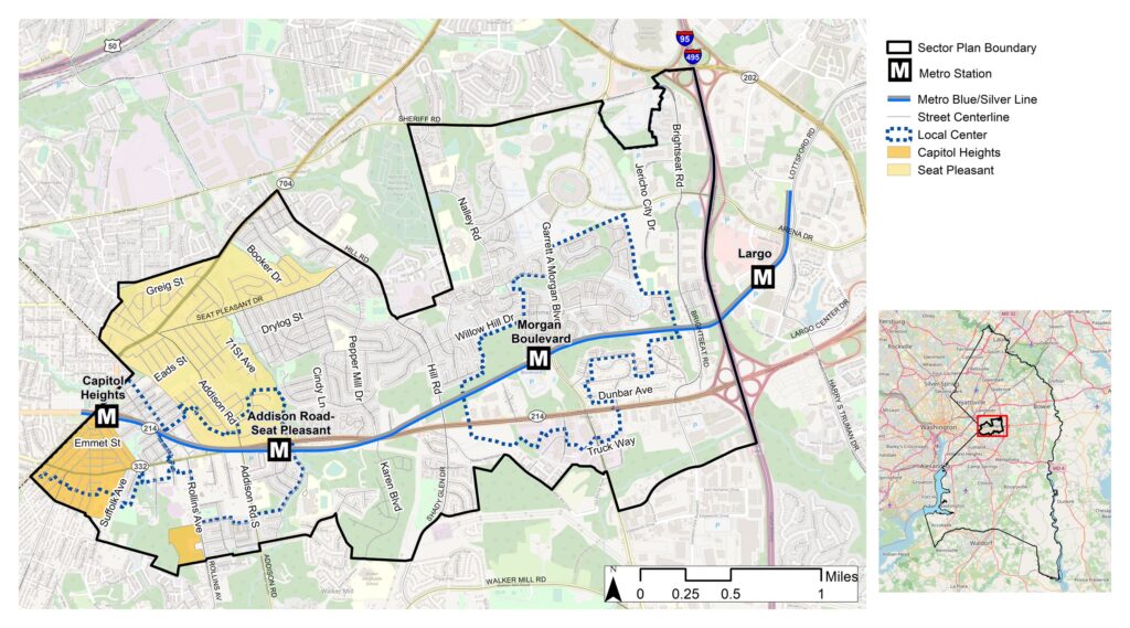
The sector plan area is located along the MD 214 (Central Avenue) corridor between Washington, D.C., and I-495 (Capital Beltway). It will focus on the areas in and around Capitol Heights, Addison Road-Seat Pleasant, and Morgan Boulevard Metro Stations, as well as Commanders Field. To see a map of the sector plan boundary, click the above Maps tab.
The area’s three Metro stations and select properties surrounding them are designated Local Transit Centers by Prince George’s 2035 Approved General Plan (Plan 2035). Local Transit Centers are defined by Plan 2035 as mixed-use areas that are well connected by transit and offer local-serving retail, limited office uses, and a mixture of medium-density housing options. The new sector plan will reflect the vision and goals contained in Plan 2035, including focusing on new development in designated centers and preserving existing neighborhoods, and will amend applicable countywide functional master plans.
The SMA is a process that facilitates the rezoning of properties within a plan’s boundary. Typically, this process results in a zoning change for only a few properties, and the remaining properties keep their existing zoning classification.
Now that the sector plan and SMA have been authorized by the Council, the plan preparation process has commenced. The project team will begin to implement the public participation program, and all interested citizens are encouraged to participate in the planning process. Public input meetings and events will be scheduled both in person and virtually throughout the summer and early fall of 2023. Additional online input exercises will be made available as well. The project team is excited to begin working on this project and hear what the community has to say!
Central Avenue – Blue/Silver Line Sector Plan Video
Check out our project team members as they introduce the Central Avenue-Blue/Silver Line Sector Plan!
The Central Avenue-Blue/Silver Line Sector Plan will be a guiding document developed through a multi-year public engagement process, extensive review, and public hearings. The sector plan will address future development in and around Capitol Heights, Addison Road-Seat Pleasant, and Morgan Boulevard Metro Stations, designated as Local Transit Centers in Plan Prince George’s 2035 (Plan 2035). This plan will also focus on FedExField and the Central Avenue corridor.
Over the past decade, several studies, reports, and implementation strategies have been completed. However, a sector plan has yet to be adopted for the Central Avenue-Blue/Silver Line area. The existing documents will be major building blocks for developing this sector plan, thereby solidifying many of the key findings, recommendations, and strategies detailed throughout the reports.
This plan will entirely replace the 2008 Approved Capitol Heights Transit District Development Plan and Transit District Overlay Zoning Map Amendment and supersede (within the project boundaries) the 2010 Approved Subregion 4 Master Plan and Sectional Map Amendment. It will reflect the vision and goals of Plan 2035, including focusing on new development in designated centers and preserving existing neighborhoods. This new sector plan will examine the area’s existing conditions, issues, opportunities identified by community members and other stakeholders, and market potential, and develop a vision and goals for future growth and preservation, along with specific and focused policies and strategies to achieve those goals.
All properties within Prince George’s County outside of the City of Laurel were rezoned on April 1, 2022, to the new zones contained within the County’s adopted 2018 Zoning Ordinance through the Countywide Map Amendment (CMA). A sectional map amendment (SMA) is being conducted concurrently with this plan should properties require further zoning changes to implement the recommendations of this sector plan.
The lack of development and growth that has occurred in this area since the 2008 Approved Capitol Heights Transit District Development Plan and Transit District Overlay Zoning Map Amendment implies there is a critical need for updating land use and planning recommendations to incentivize and guide future development within this key area of Prince George’s County.
Project Timeline
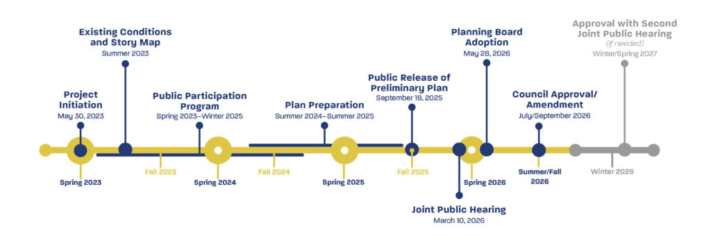
| Phase | Date |
|---|---|
| Approval with Second Joint Public Hearing (if needed) | Winter/Spring 2027 |
| Council Approval/Amendment | July/September 2026 |
| Planning Board Adoption | May 28, 2026 |
| Joint Public Hearing | March 10, 2026 |
| Public Release of Preliminary Plan | September 18, 2025 |
| Plan Preparation | Summer 2024 – Summer 2025 |
| Public Participation Program | Spring 2023 – Winter 2025 |
| Existing Conditions and Story Map | Summer 2023 |
| Project Initiation | May 30, 2023 |
Project Boundary Map
Welcome to our Resources Center!
Here is information about the planning process for the Central Avenue-Blue/Silver Line Sector Plan in Prince George’s County. Below are resources showing what the planning team has been working on.
March Open House Events
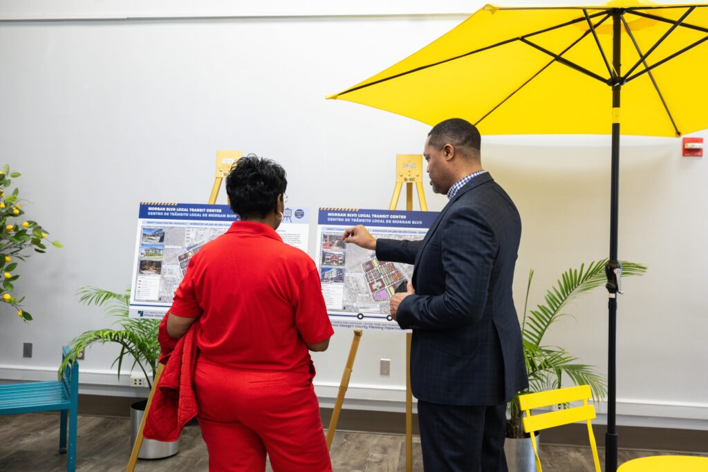
On March 13th and 16th, 2024, the project team hosted an open house at the Sports and Learning Center in Landover.
The open house was the culmination of the project’s public participation program. Project staff wanted to ensure we heard the community’s voice correctly and collect feedback on the DRAFT vision statements, planning goals, and urban design scenarios.
During the events, staff gave a brief presentation featuring a project overview, the highlights of our community engagement efforts, a market study summary, and a brief explanation of the DRAFT urban design scenarios. View the presentation here!
Following the presentation, attendees were invited to review and provide feedback on the area-wide vision and goal statements via an online or paper survey. Additionally, attendees were asked to review the Local Transit Center and Stadium Focus Area vision statements, market study findings, precedent imagery, and preliminary urban design visualizations. Check out the poster boards here!
The survey questions are based on the material presented on the poster boards. The responses to the survey questions will inform the plan’s visions, goals, policies, and strategies. Staff will begin to develop the plan and expect to release the initial DRAFT for public review in the Fall of 2024.
Review the summary of survey responses here in English and Spanish.
Blue Line Corridor Technical Assistance Panel (TAP) Report
The project team acknowledges this comprehensive report and values the partnership of Local Initiatives Support Corporation (LISC) DC and Urban Land Institute (ULI). In March 2024, members of the project team participated in the stakeholder interview portion of ULI Washington’s Technical Assistance Panel (TAP) program for the Blue Line Corridor. The team is reviewing this TAP Report and will incorporate recommendations, as appropriate, into the draft plan document.
Market Study
BAE Urban Economics, part of the project consultant team, is a well-established firm that has worked with public agencies, non-profit organizations, universities, and private developers across the country and here in the County. Their team conducted an unbiased assessment of the (re)development and/or improvement opportunities in the plan area through the methods below:
- Collected demographic, economic, and real estate market conditions data
- Reviewed the input received from community engagement activities
- Interviewed business owners, developers, real estate professionals, and other stakeholders in the area
- Identified and analyzed real estate activity, regional and national trends, community priorities, and development barriers and constraints
- Applied their expertise to test the feasibility of alternative development scenarios
This study reviewed the existing conditions of the local market and its future potential, investment and infrastructure needs, and community and small business needs.
Online Activity: Vision Exercise
The Vision Exercise comment period closed on January 24th, 2024, however, you can still view the draft vision statements here: https://pgplanning.konveio.com/draft-vision-statement. Watch the video below to learn more about how we arrived at this stage in the planning process.
Online Input Summary
From September 7 to November 22, 2023, the project team deployed two interactive online input activities, one using the ArcGIS Online Survey123 application and another using Slido.com. The exercises were linked on the project webpage, shared through constant contact emails and social media, included in information shared with stakeholders, and distributed at various community events in QR code form as activity business cards.
Word Clouds
The Slido.com platform allowed the community and stakeholders to use 1-3 words to build Word Clouds that represent their vision for each of the three inner-beltway Metro Stations and the surrounding area.
SWOT Exercise Summary
The ArcGIS Online Survey123 platform allowed the community and stakeholders to actively participate by dropping pins on a map to indicate strengths, weaknesses, opportunities, or threats (SWOT) within the sector plan boundary, accompanied by an explanation. Additionally, users were asked to link their comments to a Plan 2035 element.
Virtual Public Kickoff Meeting Recording and Summary
Review videos and documents from the Virtual Public Kickoff Meeting Event held on Wednesday, September 27th, 2023, from 6:00 p.m. to 8:00 p.m.
Existing Conditions Full Report
The full existing conditions report completed in July 2023, is available for reference. The report summarizes research on the area’s current state and key characteristics.
Planning in Prince George’s County
The Prince George’s County Planning Department is working tirelessly to create the communities of choice you know and love. We want to provide our residents with all the resources they need to remain informed and a part of the process by which their communities develop and grow. Below are some resources that can help you navigate the planning process and learn about current initiatives.
What is M-NCPPC?

Citizens’ Handbook
Housing Opportunity for All / Oportunidad de Vivienda para Todos
Previous Plans and Studies
The Central Avenue-Blue/Silver Line Sector Plan will replace the 2010 Subregion 4 Master Plan and Sectional Map Amendment, 2008 Capitol Heights Transit District Development Plan, and 2000 Addison Road Metro Area Approved Sector Plan. You can view the plans at the links here to see previous recommendations for the area.
The sector plan will build on the conclusions of multiple studies completed within the last 15 years.

For more information about this ongoing project and how you can be involved, please email the project team at CABL@ppd.mncppc.org.